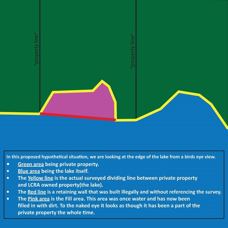
Understanding Fill Area:What Is “fill” area?“Fill” area is land that may exist between the rear boundary of a waterfront property and the water’s edge, to which the upland property owner doesn’t rightfully have title. According to LCRA, “fill” is most commonly found on Lake LBJ, with very few of these tracts remaining on Lake Travis. How is “fill” property formed?There are a few possible explanations for why these “fill” tracts exist. The Lower Colorado River Authority (LCRA) has, from time to time, systematically lowered Lake LBJ to allow homeowners the opportunity to do routine maintenance on their waterfront. During this time, property owners who have improved their waterfront by having a retaining wall constructed may have built out into the riverbed (as the lower water levels may allow) instead of along the surveyed rear property boundary. The area between the retaining wall and the existing shoreline is then “backfilled” to create additional land. “Fill” property can also be created through accretion, which is the gradual addition to land through natural causes. How do I know if “fill” area exists on a property that I am potentially purchasing on Lake LBJ?If there is an existing survey showing all current improvements, it will likely reveal if “fill” may exist. If a survey is not available, it is always advisable to obtain a new one, for reasons that exist beyond understanding this topic. When waterfront improvements extend beyond the legal boundary as shown, it is recommended to understand who owns the property which they encroach. Who owns “fill” tracts?A common misperception is that LCRA (Lower Colorado River Authority) owns ALL of the area under Lake LBJ. While they do own the large majority, it has come to light in recent years that this is simply not the case. When Lake LBJ was originally formed, there were some homeowners that didn’t want to sell their property to LCRA, but they did grant them an “inundation easement” to cover the property below the 825’ elevation line. If “fill” area does exist on my property, what can/needs to be done?If it is determined that the area beyond the legal boundary is owned by LCRA, board approval is required for them to sell this property to the upland/adjacent owner. A metes and bounds survey of the “fill” tract is first required to determine the size of the property, which is usually less than a tenth an acre. LCRA will then go to the upland tract (along with verifying the property value of several surrounding tracts) to determine an appropriate price/acre to be charged for the “fill” tract. It should be noted that this process can take several months to complete as the board only meets a 3-4 times a year. If it is found that the “fill” property is privately owned, further research will need to be conducted. The bottom line…make sure you get a survey and deal with a knowledgeable agent from The Lakefront Group to guide you thru this and many other lake exclusive hurdles.
Create an AlertBy selecting “Text” or “Email and Text” in the “Send Results By” section of this form I agree to received automated listings via Text. This agreement is not a condition of purchase. Receive up to 31 messages per month per search saved. Reply STOP to opt out or HELP for help. Message & data rates apply. Terms and privacy policy found at www.lakehouses4sale.net/privacy-policy.php. |
Leave A Comment